
On the River Thames, near Rotherhithe, Surrey • November 26th, 1796, a Saturday, almost sunset
See how the river Mists waft and weave in the light of the Waterman’s Lamp. See how the Tobacco alight in his Pipe brightens and fades. It is a credit to the man’s Constitution that he smokes, since he surely needs the full Capacity of his Lungs to row his Wherry against the turning Tide. I have no Pipe, yet my Breath also smokes in the cold air. You, my Dear Guest, were wise to bring such a great thick Cloak. Why, its Hood is so capacious, I cannot see your Face, let alone your Breath! Wrap your Garment closer. It is not the most pleasant Evening to be on the Thames, and I fear you are uncomfortable.
To my mind, however, a Water Journey is by far superior to crossing by Bridge in a Hackney-Cab and suffering the Ordure of the streets through Southwark and Bermondsey to reach our Destination. Besides, the Wherryman’s fare is only sixpence for the two of us![1] Nothing compares to this Mode of Travel for imbibing the Atmosphere of our journey’s end. We have but several Miles to row Downriver to the ancient Parish of Rotherhithe, in the County of Surrey.
Variously known through the ages as Retherhithe, Ruherhithe, and Rotherethe, but also as Rederith, Redrith, Redruth, and Redryff, it is sometimes referred to as Redriffe even now.[2] One of my Consultants, Mr. Daniel Lysons, has told me that Rotherhithe derives its Name from the Saxon words rother, a sailor, and hyth, a haven or wharf. It remains apt. Let me acquaint you with the Vicinity.
We are approaching Docklands, consisting of 11-Docks in all, where Ships lay at Anchor or under Construction—including some for the East-India Company. From these Docks, Whalers leave and make Port; Barges ferry Goods; and Watermen like our own ply their Trade. Here be Sailors and Ship’s-Masters such that leave for, and return from, the High Seas, sometimes with Prizes and sometimes naught, but the luck (or not) of remaining alive.
Rotherhithe is a place where Men of all manner of Nautical Trades make their Livelihood. Why, Mr. Lysons goes so far as to claim that “The whole extent of the shore is inhabited by various artificers and tradesmen who make and furnish rigging and provisions for the navy”.[3]
Of course, they are not the only Denizens of the Parish. Needless to say, there are Landlords, Merchants, Victuallers, Apothecaries, Smiths of myriad variety, Market-Gardeners, Cow-Herds, & Beggars, too. And then there are Wives, Widows, Sweethearts, Mistresses, Prostitutes, Children, Invalids and the Old. Life can be prosperous for those who support England’s Naval Might. For others, it can be hard.
Beyond the immediate Environs of the Docks—in regard to which Mr. Lysons estimates there were some 1600 houses in Rotherhithe 4-years ago, viz. in 1792—the Land is marshy. The Meadow is principally used for Pasture, but some is taken up for Market-Gardens. By 1824, a portion of the Marshland will be claimed for more Docks and Ponds.
One of my Guidebooks—Volume VI of Mr. Edward Walford’s Old and New London—informs me that at the present time or thereabouts, the Parish consists of “a few streets, with good gardens to the houses, extending from the Blue Anchor-Rd. (the boundary between Bermondsey and Rotherhithe) to Hanover-St.”.
He locates its southern Extent at Paradise- and Adam-St., “leading from Blue Anchor Road to the end of the Deptford Lower-Road”.[4] A narrow Pathway known as the Halfpenny-Hatch follows a similar Route through the Fields, passing by a Public-House known as China Hall and ends at the Dog and Duck tavern. Mr. Walford hears tell there was a Theatre nearby in the ’70s, where a Play could be enjoyed for as little as 1-shilling in the Gallery. Unfortunately, it burned down in 1778.
But enough of History, my Friend. We have arrived! Gather your Wits as well as your Belongings, for there are Stairs to climb. Oh, please, do take care on the Steps! Even though it is not long past High-Tide, the ebb-tide has already left Weed and Debris upon which the Unsuspecting might slip.
This is Greenland Dock, formerly part of the Howland Great Wet Dock. It is presently named for the Whalers returning from Greenland with Whale-Oil to light our Lamps, one of which will light our Path tonight. These Waterman’s Stairs are named for it, too. Mr. Lockie has assured me they provide the most economical Route to our destination, Trinity-Street. He told me that the “continuation of Lower Queen-St. being parallel to the Thames, it leads to Russell-St. and Greenland Dock”.[5]
Follow me, dear Traveller. Though we tread the quieter reaches of Rotherhithe, fear not—there is little danger of being waylaid by dark Lanes or unsavoury Characters. This Passage leads directly to Trinity-St., from which only a few steps separate us from our Destination: the United Society’s School.
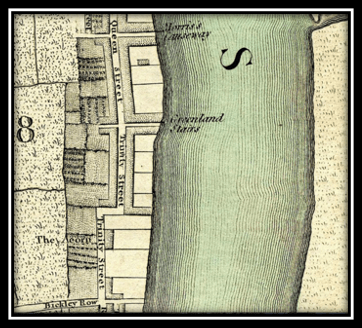
Figure 1. Location of the Greenland Stairs and Trinity-St., Rotherhithe. Detail from Cary’s New and Accurate Plan of London And Westminster 1795
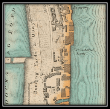
Figure 2. Location of the United Society School, Trinity-St., Rotherhithe. Detail from Map of London, Made from An Actual Survey in the Years 1824, 1825 & 1826, C. & J. Greenwood
§
Reader, allow me to confide in you. I rely entirely on Mr. Lockie’s directions to our Destination! I must commend his eponymous Topography of London, &c., &c. It provides a much more fulsome Directory to this Parish than most other such Publications. Messrs. Langley and Belch, for instance, seem to assume that “Greenland Dock” provides sufficient Orientation to Trinity-St. for Strangers![6]
The Pot calling the Kettle Black, you say? Reader, you do not refer to your Narrator, surely? Yes, very well, I concede that the Scope of these Maps is insufficient to shew the present Vicinity in its Relation to either its Parish or the City of London. But had I offered a more expansive View, why, the Location of the Greenland Stairs, Trinity-St., and a certain Site on that Street, would be shrunk much too Small to see.
What, you have a further Complaint? I commend your Diligence. Most readers to not attend to Captions for Figures, let alone read Footnotes. No, my Companion is neither aware of the Anachronisms, nor shall I apprise that Person of them. No need to splutter! I understand the Logic of your objection, but the dates of my Sources are not too long before or after the Fact of this present Journey.
If Criticism is due, surely it must be levelled at the Map-Makers of the Times. All too often, Trinity-St. is unnamed or absent, obscured by an inconvenient Crease or by the thoughtless Location of the Key to the Map. I have seen early Drafts of Mr. Wallis’s Map of London—he anticipates publication in 1801—and argued very strongly against his Decision to put a Table shewing the latest Hackney-Coach Fares in Rotherhithe. I fear he will not listen to Reason.[7]
These Cartographers seem to forget about the Longevity of their Craft. Do they anticipate the Confusion of future Tour Guides, Genealogists and Historians, the Cost to Posterity and Clients, not to mention the present Inconvenience to your Narrator? No, they do not! This makes an Anachronistic Map of Rotherhithe preferable to a Contemporaneous one in which the Location of Trinity-St. is compromised by the diverse Factors I have enumerated. But Look—we have arrived at our Destination! This must put an end to our Conversation, for I must attend to my Client.
§
This, my Friend, is the United Society’s School. It exists thanks to the Beneficence of Mr. John Russell, the 4th Duke of Bedford,[8] and apparently the 5th Duke, Mr. Francis Russell, as well.[9] It is also supported by Charitable Subscription. In 1849, it will merge with another local educational Institution, the Amicable Society School.
In my humble opinion, this is a very modest Edifice, possibly of minor historical Importance to interested Parties, but surely none Aesthetic. It is true, it was built during a period of architectural Restraint and I also admit that it can be hard to appreciate the merits of a Building scarcely more than 40-years-old, since such Structures tend to look merely unfashionable. Nevertheless, this School-House seems not so much influenced by Neo-Classicism as it does Puritanism, and if not that, then pure Thrift.
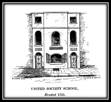
Figure 3. The United Society’s School, Rotherhithe
There it stands, 3-austere-storeys-high, with no Garden in front. Two Doors and one—admittedly arched—Window to the street; three more above. There are two run-of-the-mill square Windows on the topmost floor, separated by an unnecessary expanse of bare Wall. At our feet is a large Grate. Is there a gloomy Kitchen below or merely a Cellar for storage?
Perhaps the austerity of the Building reflects the use to which it is put, viz. as a Charity School for the sons of Mariners, Shipwrights and Allied Trades? Be that as it may, neither the School-House nor the History of the School, though naturally Objects of Curiosity, are the prime Reason for our Journey here this evening. Rather, it is the School-Master, a certain Mr. Greensword.
[1] Kearsley’s Gentleman and Tradesman’s Pocket Ledger: For the Year 1797, printed for G. Kearsley, no. 46, Fleet-Street, p. 146.
[2] “Rotherhithe”, in A History of the County of Surrey, Volume 4, ed. Mr. H. E. Malden, London, printed by Victoria County History, 1912, p. 83. Reader, I should add that one of my expert Consultants, Dr. King, an expert in Languages, has queried whether “Ruherhithe” should be spelled “Rutherhithe”. I have attempted to raise the Issue with Mr. Malden, but he is no longer answering my Letters.
[3] Mr. Daniel Lysons, “Rotherhithe”, in The Environs of London, being an Historical Account of the Towns, Villages, and Hamlets, within Twelve Miles of that Capital Interspersed with Biographical Anecdotes, Volume 1, County of Surrey, London, printed by Mr. A. Strahan for Mr. T. Cadell, 1792, p. 470.
[4] Mr. Edward Walford, “Rotherhithe”, in Old and New London: A Narrative of its History, its People and its Places. Illustrated with Numerous Engravings from the Most Authentic Sources, Volume 6, London, Messrs. Cassell, Petter & Galpin, 1878, p. 135.
[5] Mr. John Lockie, Lockie’s Topography of London: A Concise Local Description of and Accurate Direction to every Square, Street, Lane, Court, Dock, Wharf, Inn, Public-Office, & c. in the Metropolis and its Environs, including the New Buildings to the Present Time, upon a Plan Never Hitherto Attempted. &c., printed by Mr. S. Couchman, Throgmorton-Street, London, 1810. Sold by Messrs. G. and W. Nicol, Pall-Mall; W. Miller, Albemarle-Street; J. Hatchard, Piccadilly; J. White and Co., Fleet-Street; J. Mawman, Poultry; J. M. Richardson, Cornhill; and Darton and Harvey, Gracechurch-Street.
[6] Langley and Belch’s Companion to their New Map of London, on an Entire New Plan, From Actual Survey to the Present Time, etc. etc. Printed for and by Messrs. Langley & Belch, no. 173, High Street, Borough, and may be had of Booksellers and Stationers in general, 1812.
[7] Wallis’s Plan of the Cities of London and Westminster 1801, publisher Mr. John Wallis, no.16 Ludgate Street.
[8] Mr. Edward Blick, A Short Account of the Churches, Schools, & Charities, in the Parish of St. Mary, Rotherhithe, Surrey, published by Seeleys, no. 54, Fleet Street, & no. 2, Hanover Street, London, and Mr. B. Blatt, no. 33, Rotherhithe Street, printed by Messrs. Catline and Cook, Old Kent Road, 1848, p. 47.
[9] Whereas Mr. Blick dates the Establishment of the School in 1755, Mr. Edward Josslyn Beck, M. A. reports Francis, Duke of Bedford, gifting the land for the School-House and School-Room, by indenture, on the 1st of July, 1791. This creates a degree of Ambiguity about the School building, but since Mr. Greensword is a School-Master there post-1791, and Mr. Blick’s volume was published in 1848, the image of the School is clearly accurate. Of interest, by-the-by, is that “the inscription over the door of the schoolmaster’s house still records the gift, and the School remains to this day as a boys’ school in connection with Holy Trinity Church.” See Mr. Edward Josslyn Beck, M. A., Memorials to Serve for a Parish History of St. Mary, Rotherhithe, in the County of Surrey and the Administrative County of London, With a Chapter on the Geology of the Thames Valley and of Rotherhithe, by the Reverend T. G. Bonney, With Numerous Illustrations, Cambridge at the University Press, 1907, p. 168.

Why, it is true that the United and by association Amicable Society School does bare such an unnecessary expanse of wall at the third story. Bald perhaps in it’s conclusion, made from such height, that to be sparse in definition at the top was of the fashion and that those men in hats simply had roofs just like it’s sturdy self. Lucky for us readers that our eyes are lowered, set in motion by curiosity and have a very clear and exciting path to follow, set out by our honourable narrator; we are knocking at the door in hopes that Mr Greensword is indeed available and so by both accounts must no longer be confronted with the architectural thrift of the neo-classical era.
Yours sincerely,
Reader
LikeLiked by 1 person